The Host Laboratory for the Ebro-Llobregat Deltaic System Supersite will be the Universitat Politècnica de Catalunya.
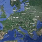
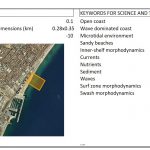
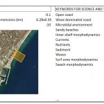
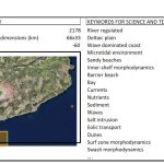
The Supersite covers an instrumented, urban section of the Catalan coast with two river-delta systems: the Ebro in the south and the Llobregat. The Ebro is the longest Iberian river discharging into the Mediterranean Sea, draining a catchment of about 86,000 km2. At its mouth, it forms one of the largest deltas in the Mediterranean, approximately 320 km2 in area, which is triangular and with branching lobes resulting from the interaction between sedimentation processes, marine hydrodynamics, climate and human activities. Its peculiar geomorphology and the variety of natural systems and dynamic processes found in the Delta turn it into an important ecological asset, included in the List of Wetlands of International Importance designed under the Ramsar Convention. The strip of coastal land on the delta plain is protected by its designation as Natural Park, a Plan for Areas of Natural Interest (PEIN) and a Natura 2000 site, and includes several natural reserves and protected wetlands.
The hydrology of the Ebro is affected by the large climatological and topographic heterogeneity of its basin, and by upriver reservoirs and a high level of abstraction. Over the last century reductions in river flow and sediment input have ended the growth of the delta, and led to its reshaping by erosion by sea waves and currents. At the mouth, the Delta coast is retreating at a rate of a few metres per year. The combination of subsidence due to sediment compaction and sea level rise associated with global change poses a significant threat on such a low-lying coast.
The Catalan coast is instrumented with a network of deep water buoys (Puertos del Estado) and shallow water buoys characterizing mainly harbour entrance routes. It also includes a high frequency radar deployed at the Southern boundary (Ebro Delta) and a central laboratory (OBSEA) to observe a variety of hydrodynamic and ecologic parameters. The Northern boundary is controlled by the Meteorological and Oceanographic station from the Spanish National Research Council (CSIC) that also deploys instruments to record physical and ecological parameters along several transects. This data structure is complemented by a set of numerical models (wind, waves and currents) that reproduce operationally and offline the main meteorological and oceanographic fields along our coast and extending down to the continental shelf. These models have been applied to offline analyses and also form part of the operational services offered by central and regional institutions.
The Supersite will facilitate activities and provide services, as follows:
- hydraulic (numerical and physical at all scales) modelling of waves/currents;
- monitoring hydrodynamic and morphodynamic processes in a transect from about 1,000m water depth to shoreline;
- transport modelling for passive and active particles to predict impacts such as erosion, flooding or pollution;
- collection of field observations to characterize events and longer term trends;
- high resolution modelling to predict synoptic patterns;
- impact assessment based on observations and modelling; and
- educational transfer, combining observations and models to train young researchers and for Masters and PhD theses